The Ocean Is Us
MAP Office
We sweat and cry salt water, so we know that the Ocean is really in our blood.—Teresia Teaiwa[1]
Swimming, floating, fleeing, sinking: how to absorb those affected by climate change?
Taking as a point of departure the effects of environmental change and migration, we would like to outline a new map with a set of possibilities. Turning our back to the land in order to absorb the sea as a new territory, this visual essay presents a series of works based on the concept of “Liquid Land—Solid Sea.”
The history of the twenty-first century will be written with water. As sea levels rise, the sea becomes our new desert. When Paul Virilio announced the “end of geography,” he opened a new perspective in which time precedes space.[2] Time is now on top of space, just as the sea sits on the surface of the Earth. Virilio was referring to a new age in which information technologies, combined with an economy of speed, would eclipse the long-established domination of space. In the context of MAP Office’s research on islands and the ocean, we have established a parallel between the dematerialized and the digital using the liquid terrains that are the seas and oceans.
The development of globalization led to the acceleration of two types of mobility: the informal and the human. The Internet introduced a communication speed revolution but also shrank distances and opened up possibilities to work abroad, as well as dislocated families across the globe, especially in international cities like Hong Kong that expanded along shorelines and rivers. Living and working in Hong Kong, one of the highest density cities in the world, we drew a clear connection between the flux of migrants and the role interconnected islands played in absorbing this flow.
The question of migration has always been related to water and coastlines. With each appropriated island, whether forced or voluntary, a networked panoply of tools and cultures existed that directed the past and the future of the island and its surroundings. Certainly, this fusion extends far beyond simple human displacement. One of the most fascinating phenomena we observed during a guided geology hike on Fogo Island was the lengthy displacement of massive boulders and bedrock that cruised to their final location on icebergs. Deposited by the melting of the ice, these chaotic rocks and other debris created a new landscape. This glacial recession allowed islands to surface and emerge as possible land for settlement. With the opening of ice-free corridors, along floating ice sheets traveling between continents, human migration can be traced along coastlines as well as to melting terrain along improbable routes.
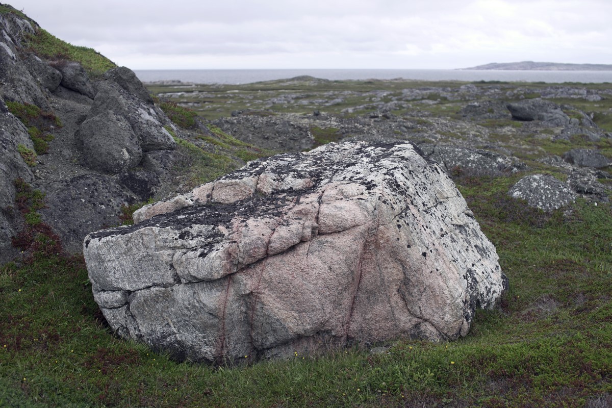
Through the many coastal hikes around Fogo Island, one can observe a 420-million-year-long history of rock contortion created by fire, ice, and the sea. According to geologists, this is a geological treasure, a rare case in which the full spectrum of the magma chamber is clearly exposed. The volcanic formation of the island was followed by an era of glaciation, when the weight of a one-kilometer-deep ice cap pushed the island 20 meters below sea level. When it resurfaced, the impact of the ice left multiple perforations, hills and depressions, which now fill up with rain throughout the year. Other evidence of the impact of the retreating glaciers includes the large rocks, which are scattered here and there, looking as though they have been dropped from the sky.
In our research, we draw a parallel between the ice age and the present rise in sea levels and warming oceans. In this sense, we would like to construct this essay as a dérive. Like seafarers, we propose a noetic cartography to connect various scales and positions, recently materialized as the sculpture Ghost Island, made of bamboo and ghost fishing nets, on the island of Krabi as part of the 2018 Thailand Biennale. This cartography is not about initiating new routes, but is intended to open up perspectives and reflections through a series of artworks:
1. Island Is Land
2. Hong Kong Is Land
3. The Ocean Is Land
4. The Ocean Is Life
5. One Ocean
1. Island Is Land
In 2008, MAP Office began a new body of work questioning the role played by islands with the statement “Island Is Land”. Following the Deleuzian concept of Desert Islands, we saw a possibility to conceptualize the “re-”, a return to the origin.[3] The “re-”, can be embedded in the figure of the castaway in two ways. The first one is spatial, the second is temporal. Through an involuntarily discovery, the castaway appears as an original figure taking possession of a new land, both a home and prison during this unfortunate exile. In this situation, the castaway is forced to domesticate the island. Re-constructing the original place or developing a utopian place, there remains no choice other than to dominate the new domain, or perish.
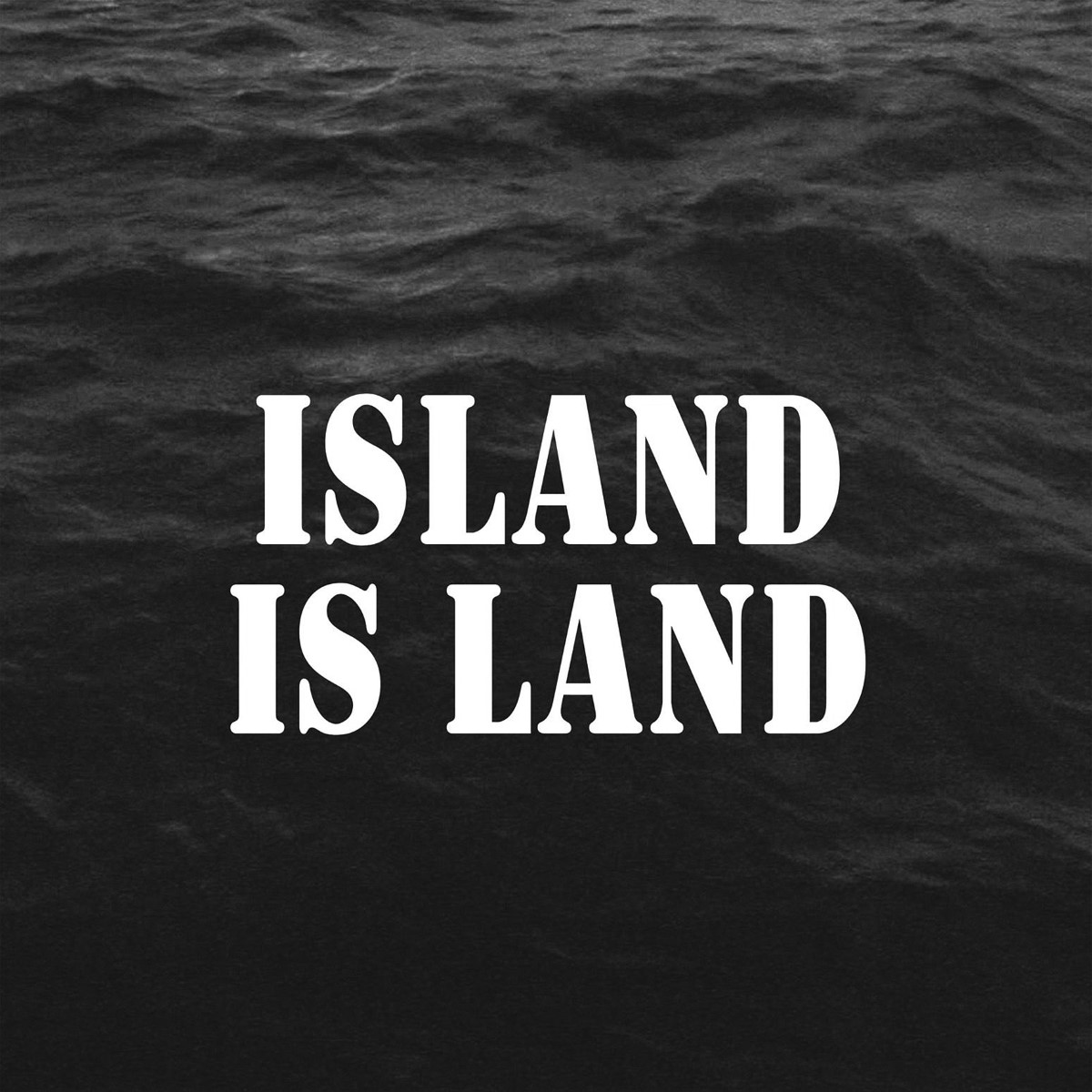
Floating against the background of a black, agitated sea, the fourteen letters that form the statement appear as a new island, emerging from the motion of a continental detachment or a volcanic perforation of the sea. From a contemporary perspective, the polystyrene lettering recalls the new land that is formed by the tons of plastic garbage that have been lost at sea.
2. Hong Kong Is Land
Artificial islands are territorial fragments, yet they are constructed and destroyed in a cycle that concentrates many of the forces that characterize human civilization. This cycle of production and destruction is a way to escape the present and to project the future. Myths, legends, stories, histories—as many narratives as possible are needed to define the contours of a new territory. In the case of the project Hong Kong Is Land, a new atlas is constructed as a way to negotiate and locate new islands within the existing watery territory of Hong Kong.[4] Our imagined new map adds eight artificial islands to the existing landscape as a result of our research into and experience of the territory over the last twenty years. Our first book, Mapping Hong Kong, analyzed and narrated temporal densities.[5] The city later became a laboratory of ideas in the two volumes HK LAB[6] and HK LAB 2.[7] These books explored the extended region with respect to its unique urban and infrastructural features.
Until 2047, Hong Kong will face many challenges generated by its unique condition as a Chinese city outside the borders of the motherland, a policy labeled as “One country, Two Systems.” Among these, exponential population growth is considered to be a significant threat to the city’s future stability. Yet Hong Kong has proven to be an elastic territory, capable of absorbing millions of migrants. In the years following the 1949 establishment of China’s new communist regime, the People’s Republic of China, as many as 100,000 people were migrating south to Hong Kong annually and for almost 2 decades, rapidly increasing its population by 2.2 million.
Today, Hong Kong’s limited land area restricts where future population growth can be housed to just three options. The first is to reclaim more land from the water, and the second is to urbanize the city’s protected parks or agricultural land, both of which have long been fought against by Hong Kong’s citizens. A third option would be to create artificial islands in portions of the city’s territorial waters that have not yet been exploited. We opted for this third approach to use Hong Kong as an island-generation case study that could subsequently be extended to the Pearl River Delta and further along the coastline of China.
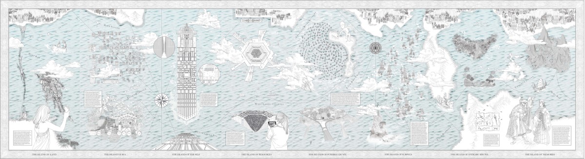
The Hong Kong Is Land project proposes adding eight new artificial islands to the city’s 263 islands. The project addresses many of the urban population’s future needs while also providing distinctive tourism hubs. They would not, however, be recognized as sovereign islands or generate their own maritime zones. More than a response to an unbalanced geography, the following eight island scenarios can be interpreted as a new language through which to explore and promote an economy of subsistence and wellbeing as a way to create and address new ecosystems. The ultimate aim of this project is to use Hong Kong’s territorial waters as a testing ground for solutions that could prove useful in other parts of the world which are facing similar challenges.
3. The Ocean Is Land
The question of water sovereignty is currently pressurizing the ocean in multiple geographical locations, especially in the South China Sea. Our third artwork statement, “The Ocean is Land”, is focused on the escalating tensions over the rich submarine terrain located between six claiming countries, i.e. Brunei, China, Malaysia, Taiwan, the Philippines and Vietnam. Borrowing elements from these ongoing fights, MAP Office has created a game of darts that allows the players to conquer the highly prized reserve of these disputed territories according to the countries that claim them.
In 2014, MAP Office participated in the fictional claim of small islands around Hong Kong Island. As part of a series of performances by James T. Hong, groups of swimmers were racing to plant sovereign flags on various rocks and beaches, mimicking the action of activists around the disputed Senkaku / Diaoyu Islands.
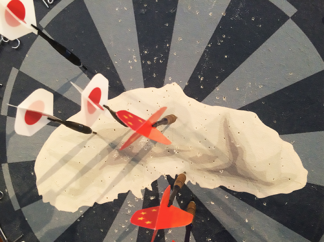
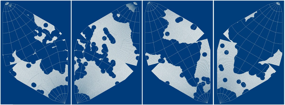
Liquid Land | Solid Sea is a research project about the current discussion about the South China Sea. What seems to be solely referring to international law[8] and ancient treaties signed by a few nations,[9] is in reality a complex territory made of islands and shoals that are barely emergent from the sea. At this point, the geography is being defined by signed papers that delineate the current ecology and economy of the region, and that shape the future geopolitical activities of the neighboring countries and beyond. For example, the Spratly Islands – subject of this cartographic representation have been in dispute since 2012, the date which China turned its back to the land to look into the neighboring sea.[10] What we thought was only the location of few islands at first, in reality includes approximately 200 islands, shoals, reefs, and sandbanks, some of which are only visible at low tide, which became apparent when starting to draw the map of the area.
4. The Ocean Is Life
Our quest for liquid territories suggests a new political construct as an alternative geography. One example is Zomia, as described by James C. Scott, a vast region that encompasses parts of Vietnam, Cambodia, Laos, Thailand, and Burma, as well as four provinces of China.[11] Zomia’s 100 million residents are minority peoples “of truly bewildering ethnic and linguistic variety,” Scott writes. In his introduction, he raises the question of a parallel research project to engage in which one could identify as a, “Zomia of the Sea,” which replaces the remoteness of the hills by the detachment or invisibility of living at sea.
Combining the sea and anthropology, MAP Office engaged in a new project about the Urak Lawoi, a fishing community which lives in Krabi National Park, Thailand, which is part of a larger group of sea nomads. This research initiated a dialogue with anthropologist Cynthia Chou and a comparative study with her mapping of the Orang Suku Laut of the Riau Archipelago in Indonesia.[12] What does it mean to be a sea nomad today, and especially in a protected archipelago visited by millions of tourists annually? We have initiated the formulation of a first answer with the interpretation of the story of one fisherman, Gung. Mapping his life in its multiple journeys has allowed us to trace a contemporary history of the region, especially around a series of federal policies devised to protect the region’s environment and culture. These policies and events include: the closure of coal mines; the interdiction of blast fishing using dynamite; the establishment of National Parks; the creation of artificial reefs; tourists’ fees; fishing regulations; and the Thai Kingdom’s long-lasting protection of minorities.
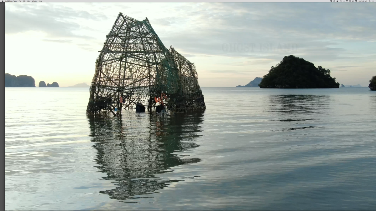
Responding to an invitation from curator Jiang Jiehong to participate into the first Thailand Biennale, titled Edge of the Wonderland, MAP Office constructed Ghost Island, an ephemeral island, to add to the existing archipelagic landscape. Made of bamboo and ghost fishing nets reclaimed from the sea, the installation recalled the particular karst geology of the surrounding islands, which were formed by the accumulation and stratification of numerous distinct layers. In just a few days, algae proliferated on the structure of the island, growing alongside the other organic life, which populated the deep tidal shoreline beach. Impressively, Ghost Island served as a natural habitat and became a stage for a film in which Gung performs actions from his everyday life inside and around the island.[13]
Living on Ghost Island, as opposed to living on land, combines ideas of both isolation and protection. In the 40-minute-long film, Gung is able to unfold a complete daily routine, which is his new life in this seaside habitat. Fishing, cooking, resting, preparing his fishing gear, and many other combinations of activities are performed from the belly of the island. In the middle of the bay, inside Ghost Island, Gung tells multiple stories, myths, and legends to visitors and swimmers. The tale of the giant snake catching fisherman during their rest, the second devastating wave that engulfed dozen of his relatives, the dancing cuttlefish, and life in the coal mine, these are stories that need to be told orally so as not to be forgotten.
5. One Ocean
The world’s oceans are a primary source of life. Despite covering over 70% of the Earth’s surface, and despite being the source of the same percentage of the oxygen we breathe, the ocean is still unknown to most of us. To the question “The Ocean Is Land for who?,” there is only one possible response for us: “The Ocean is Us”. With nearly three quarters of the planet composed of seas and oceans, 50% of which a common space outside national borders, it is relevant to question the idea of extraterritorial water as the next territory to preserve as a common, rather than exploit as a commercial domain, as is currently happening with activities such as shipping and deep sea mining.
Under considerable pressure from forces of privatization, MAP Office produced an updated map of Mare Liberum to visualize what proportion of the Earth still belongs to the commons. The 288 drawings composing Mare Liberum were exhibited at the Yokohama Triennale 2017 as part of a large installation called Island Resort.[14] Starting from the continental shelf, about one third of the surface (150 million square km) of the ocean belongs to Exclusive Economic Zones (EEZ). With the redefining of the external limits of the French continental shelf in areas rich in hydrocarbons and rare earth, sovereign nations are still continuing to gain further control over the ocean.
Teresia Teaiwa quoted in Hau’ofa, Epeli. We are the Ocean: Selected Works. Honolulu: University of Hawaiʻi Press. 2008. ↑
Virilio, Paul. The Original Accident. Cambridge: Polity. 2007. ↑
Deleuze, Gilles. Desert Islands: and Other Texts, 1953–1974. Los Angeles: Semiotext(e). 2004. ↑
MAP Office, Hong Kong Is Land, was a special commission for the exhibitions Uneven Growth, MoMA, New York, 2014. ↑
Gutierrez, Laurent and Portefaix, Valerie (eds.). Mapping HK. Hong Kong: MAP Book Publishers. 2000. ↑
Gutierrez, Laurent, Manzini, Ezio and Portefaix, Valerie (eds.). HK LAB. Hong Kong: MAP Book Publishers. 2002. ↑
Gutierrez, Laurent, Portefaix, Valerie and Ruggeri, Laura (eds.). HK LAB 2. Hong Kong: MAP Book Publishers. 2005. ↑
United Nations. Convention on the Continental Shelf. City. 1958. ↑
We are referring to the Treaty of Paris (signed in 1899), and the Treaty of Washington (signed in 1900) in which the Americans on the one hand and the French on the other reset maritime boundaries between the Philippines and Vietnam. ↑
The Paracel and Spratly Islands are a group of about 400 small coral islands and reefs. ↑
Scott, James C. The art of not being governed: an anarchist history of upland Southeast Asia. New Haven, CT: Yale University Press. 2011. ↑
Chou, Cynthia. Indonesian Sea Nomads: Money, Magic and Fear of the Orang Suku. London, New York, NY, and Leiden: Routledge. 2003. ↑
MAP Office, Ghost Island, HD video, sound, 40 min, 2019 ↑
MAP Office, Mare Liberum, 288 drawings on Hahnemuhle Art Paper (24 x 12), each 25 x 25 cm, 2017. ↑
Originally published in Parse Journal, Issue 10 2020
Related works: